How did Wittering’s geological features make quarrying a possibility, and what made Wittering stone worth quarrying in the first place?
Introduction
This first article in a three-part series aims to establish the backdrop to why quarrying took place in and around Wittering village. First, the geological properties which made this region such a fruitful source of building stones are studied. Following this a range of sources are used to establish types of stone quarried in the region before focusing on building stones sourced in Wittering specifically. This will lead into the second part in this series focusing on how, and where, quarrying took place in Wittering.
Geology of the Local Area
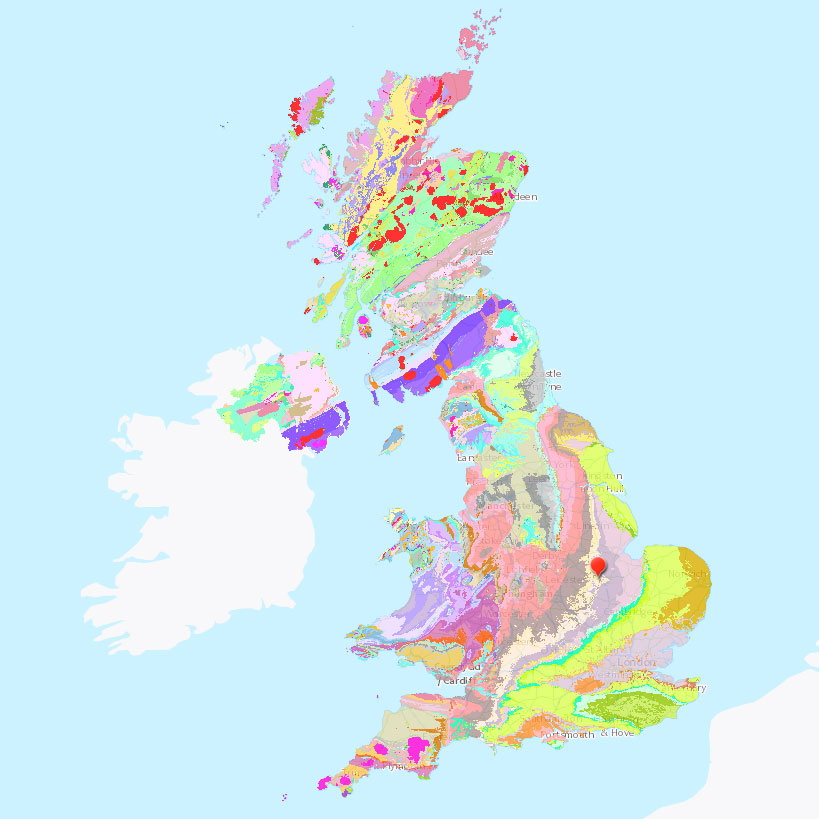
The British Isles boast diverse geology owing to an eclectic history which has seen its landmass forming part of mountains, deserts, tropical seas, ice sheets, and more over the course of a billion years. This diversity has had a big influence on economic development since civilisation reached the islands[1]. A map of bedrock geology across the British Isles demonstrates how rich this diversity is:
Contains British Geological Survey materials © UKRI 2021
Colours in the map shown in Figure 1 correspond to different bedrock types. Of interest is the yellow-cream band running from Dorset in a meandering north-easterly direction to the Humber estuary. Wittering’s location is indicated by a red pin. This yellow-cream band corresponds to various sedimentary rocks of the Inferior Oolite Group, a collection of various sandstones, siltstones, limestones, and ironstones deposited during the Middle Jurassic period approximately 170 million years ago[2]. A closer look at this band of limestone bedrock (seen below) shows how the material is dispersed through the region in greater detail.
Contains British Geological Survey materials © UKRI 2021
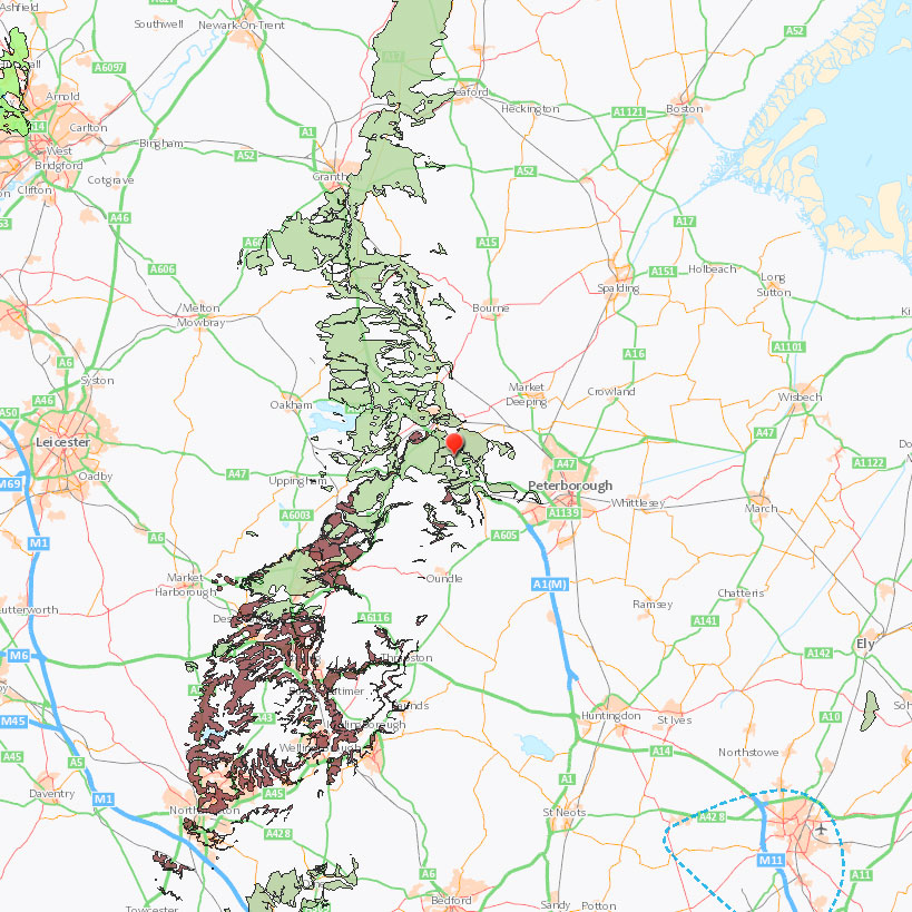
Wittering is indicated by a red pin in the centre of the map in Figure 2. Mint-green colouring indicates bedrock deposits of limestone from the Jurassic period. Red-brown colouring indicates ironstone, a fellow sedimentary rock with comparable properties but containing more than 15% iron. An even closer inspection of the local area surrounding Wittering shows where exactly limestone deposits lie:
Contains British Geological Survey materials © UKRI 2021
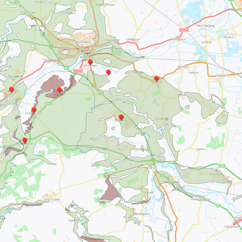
From left to right (west to east) on the map shown in Figure 3, quarrying sites include Ketton[3], Duddington, Collyweston, Easton on the Hill, Wothorpe, Burghley Park, Wittering (at the map’s centre)[4], and Barnack[5]. Though these quarries have all been in operation at different points in history and for varying durations, it is clear the geological resources of the region have been exploited.
Within the area shown in Figure 3 bedrock belongs to the Lincolnshire Limestone Formation, a formation within the Inferior Oolite Group. Building stones within this formation include Lincolnshire Limestone, Barnack Stone (‘Barnack-rag’) and Wittering Pendle[6]. Within this formation are two distinct groups of limestone, the Upper and Lower Lincolnshire Limestone formations, which boast distinct properties.
Upper Lincolnshire Limestone was quarried at sites including Ketton[7] and Barnack[8]. Both of these stones boast excellent hardness and durability. In the case of Ketton Stone, its ‘even’ structure allows it to be cut or sculpted into any direction, making it an excellent choice for everything from detailed sculpting in buildings of high status to its use as a rubble stone for vernacular buildings of the region. Barnack stone was similarly versatile with three varieties of the stone owing themselves well to a comparable variety of uses.
Stones from Collyweston and Wittering belonged to the Lower Lincolnshire Limestone group. Stones of this group exhibit a fine-to-medium grain, hardness, and fissile properties. In the case of Collyweston, the stone’s hardness, smoothness and fissility owed itself well to being used as a roofing ‘slate’. At Wittering the stone was more suitable for conventional building purposes[9], but we’ll now take a closer look at the uses of Wittering stone in particular.
The Properties of Wittering Pendle Stone
The question that naturally follows is what exactly made stone from this region worth quarrying? Wittering stone does not share the same esteemed reputation as renowned stones from the likes of neighbouring Collyweston, Barnack, and Ketton, there are nonetheless various written records referring to Wittering stone, its properties, and its role as a building stone.
One of the earliest written sources encountered during research was an article by Samuel Sharp published in 1873. Sharp describes a series of ‘very shallow’ quarries which had already fallen into disuse by the time of writing. He describes the ‘Whittering Pendle’ stone quarried around the village, noting that while it had been considered identical to Collyweston Slate, it “is very different in its mineral character, being very hard, crystalline, and sometimes almost cherty in texture.”[10] In The Geology of Building Stones (1910), Howe describes Wittering Pendle as “a less fissile, calcareous, sandy flagstone.”[11] Judd’s The Geology of Rutland (1875) describes a “beautiful, hard, and siliceo-calcareous rock known as ‘Pendle’”[12] occurring at Wittering Heath (an area of the immediate north of the village corresponding to the present-day location of the RAF base and airfield). Woodward’s The Jurassic Rocks of Britain (1894) speaks of a “tough flaggy calcareous sandstone” being extracted in thick slabs from shallow quarries[13]. On this matter, Sharp elaborates that the stone was extracted in slabs around one to two inches thick[14].
The Royal Commission on Historical Monuments of England (RCHME) performed a survey of buildings in Stamford in the late 1970s. In this they list the main building materials used in Stamford’s historic centre, one of which is a “distinctive fissile sandy limestone known as Pindle” which was dug in Wittering in the early 19th century. The survey describes a “fine and hard stone… seldom more than 2 ins. thick” which gives “a pleasant texture to the wall surface.”[15]
Howe suggests Wittering Pendle was extracted from the same beds as Collyweston Slate[16] while Woodward lists Wittering as one in a series of nearby villages which were exploited for the stone.[17] This presents possibilities of Wittering Pendle being found ‘accidentally’ during exploratory digs for Collyweston Slate in the Wittering locality, though it is impossible to say for sure without evidence. Jefferson notes that there are no quarries in or around Wittering which were specified as being used for Collyweston Slate in particular[18] so it may only have been extracted from Wittering quarries in negligible quantities.
From this evidence it can be concluded Wittering Pendle was a hard-wearing flagstone of around one to two inch thickness, with a mixture of calcareous and siliceous properties, but what can be said of its uses? Woodward spoke of the stone being used for piggeries and paving[19] while Sharp describes a similar use “for the door-slabs and rough floors of cottages, for back kitchens, &c.”[20] Historic England’s Building Stone Atlas does note an alternative use for the stone in external building, but this usage is seldom seen and is restricted to the local area.[21] While usage may have been infrequent, there are a handful of examples of Wittering Pendle stone in buildings across the region, which will be explored in detail in Part 3 of this series.
- Mark Woods, and Jonathan Lee, ‘The Geology of England – critical examples of Earth History – an overview’, in Proceedings of the Geologists’ Association, 129.3 (2018), 255-263, <https://web.archive.org/web/20190430055638/https://nora.nerc.ac.uk/id/eprint/520297/1/NORA_ARTICLE.pdf> [accessed 15 May 2022]. ⮐
- BGS, The BGS Lexicon of Named Rock Units – Inferior Oolite Group (2021), <https://web.archive.org/web/20220323175403/https://webapps.bgs.ac.uk/lexicon/lexicon.cfm?pub=INO> [accessed 18 May 2021]. ⮐
- Ketton Parish Council, Ketton Stone (2021), 2020 <https://web.archive.org/web/20201026192644/https://www.ketton.org.uk/ketton-stone> [accessed 17 May 2021]. ⮐
- Philip Jefferson, Historic Sources of Collyweston Slate (2014), <https://web.archive.org/web/20220515190532/http://www.stoneroof.org.uk/historic/Historic_Roofs/Collyweston_Slate.html> [accessed 19 May 2021]. ⮐
- Barnack Parish Council, Barnack Village History (2021) ,<https://web.archive.org/web/20210121005736/http://www.barnackparishcouncil.org/village-information/barnack-village-history/> [accessed 17 May 2021] . ⮐
- Andy King and Phil Collins, Strategic Stone Study – A Building Stone Atlas of Cambridgeshire (including Peterborough) (London: Historic England, 2019), p. 4, <https://web.archive.org/web/20210806164139/https://www2.bgs.ac.uk/mineralsuk/download/EHCountyAtlases/CambridgeshireBuildingStoneAtlas.pdf> [accessed 15 May 2022]. ⮐
- University of Southampton Archaeology, Stone in Archaeology Database – Ketton Stone (2005), <https://archaeologydataservice.ac.uk/archives/view/stones_ahrb_2005/cfm/Public/details/RockDetails.cfm?RockCode=KETTON> [accessed 28 May 2021]. ⮐
- University of Southampton Archaeology, Stone in Archaeology Database – Barnack Rag Stone (2005), <https://archaeologydataservice.ac.uk/archives/view/stones_ahrb_2005/cfm/Public/details/RockDetails.cfm?RockCode=BARNKR> [accessed 28 May 2021]. ⮐
- Graham Lott, ‘Geology and building stones in the East Midlands’, in Mercian Geologist, 15.2 (2001), 97-122, p. 114, <https://web.archive.org/web/20220515191632/http://www.emgs.org.uk/Mercian/Mercian%20-%20Individual%20papers/Mercian%20Geologist%20volume%2015%202000-2003/Mercian%202001%20v15%20p097%20East%20Midlands%20building%20stones,%20Lott.pdf> [accessed 15 May 2022]. ⮐
- Samuel Sharp, ‘The Oolites of Northamptonshire’, in The Quarterly Journal of the Geological Society of London, 26 (1870), 225-302, p. 274, <https://archive.org/details/quarterlyjourna291873geol> [accessed 15 May 2022]. ⮐
- John A. Howe, The Geology of Building Stones, (London: Edward Arnold, 1910), p. 321, <https://archive.org/details/geologyofbuildin00howeuoft> [accessed 15 May 2022]. ⮐
- John W. Judd, The Geology of Rutland, (London: Longmans), p. 173, <https://archive.org/details/in.ernet.dli.2015.222762> [accessed 15 May 2022]. ⮐
- Horace B. Woodward, The Jurassic Rocks of Britain, Volume 4: The Lower Oolitic Rocks of England (Yorkshire Excepted), (London: HMSO, 1894), p. 195, <https://archive.org/details/jurassicrocksbr00woodgoog> [accessed 15 May 2022]. ⮐
- Royal Commission on Historical Monuments of England, An Inventory of the Historical Monuments in the Town of Stamford (London: HMSO, 1977), pp. lxiv-lxix, <https://web.archive.org/web/20220515190920/https://www.british-history.ac.uk/rchme/stamford/lxiv-lxix> [accessed 15 May 2022]. ⮐
- Sharp, Ibid. ⮐
- Howe, Ibid. ⮐
- Woodward, Ibid. ⮐
- Jefferson, Ibid. ⮐
- Woodward, Ibid. ⮐
- Sharp, Ibid. ⮐
- King and Collins, p. 21 ⮐
Leave a Reply